Tuesday, April 30, 2013

Earthquakes: Magnitude and Intensity


The last days there have been many news about earthquakes at different locations. However, some of the news mix the concepts of magnitude and intensity. Magnitude and Intensity measure different characteristics of earthquakes.  Just some days ago an introduction about earthquakes was published. The present post will briefly explain the difference between an earthquake intensity and its magnitude.

Magnitude

Magnitude measures the energy released at the source of the earthquake and is determined from measurements on seismographs. It is a quantitative measure of the size of the earthquake at its source. The Richter Magnitude Scale measures the amount of seismic energy released by an earthquake. Richter scale was proposed by Prof. Charles F. Richter. The most important thing to remember about Richter magnitude is that it is a logarithmic scale, meaning that an increase of one in magnitude corresponds to a factor of ten increase in the amplitude of ground motion. Mathematically, an earthquake of magnitude x results in seismic waves with amplitudes proportional to 10^x. Image 1 shows how to get the Richter magnitude of an earthquake by reading a seismogram.

Image 1. Method to get the Richter magnitude of an earthquake.

Intensity


Intensity measures the strength of shaking produced by the earthquake at a certain location. Intensity is determined from effects on people, human structures, and the natural environment. The intensity of an earthquake at a particular locality indicates the violence of earth motion produced there by the earthquake. It is determined from reported effects of the tremor on human beings, furniture, buildings, geological structure, etc.  is variable over the area affected by the earthquake, with high intensities near the epicentre and lower values further away. This phenomenon is the result of seismic-wave attenuation, which is the reduction in wave amplitude and wave energy as they travel away from their source. In order to study the patterns of earthquake intensity during different earthquakes, a system has been devised to assign specific numbers to different levels of shaking. The Mercalli scale was developed in 1902 and modified in the 1930s. The Mercalli scale assigns a numerical value, from Roman numeral I to XII, to the intensity of seismic shaking at any one particular location. Lines of equal intensity (isoseismal lines) are not perfect circles. Image 2 shows the isoseismal of the 1947 Michigan earthquake.

Image 2. Isoseismal of the 1947 Michigan earthquake

A practical example with an everyday life situation may help to understand the concepts. Magnitude can be likened to the power of radio or television waves sent out from a broadcasting station. Intensity is how well you receive the signal, which can depend on your distance from the energy source, the local conditions, and the pathway the signal has to take to reach you.

References and Additional Reading


Thursday, April 25, 2013

Faster than the sound? Our velocity due to Earth's rotation.

We all have heard about relative motion and about relative velocity. "The continuous change of position of a body with respect to a second body or to a reference point that is fixed". 

As the Earth is always moving, we can say that we are always at relative move with respect to a reference fixed point. This post presents a simple estimation of the relative velocity of a person located at the Earth's surface with respect to the rotation axis of the Earth. 


rotation velocity


Monday, April 22, 2013

Earthquakes

April 2013 was marked by unusual high earthquake activity around the world. There were many news about earthquakes at different locations: China, Russia, Mexico and more. There are even articles suggesting explanation a new theories about earthquakes. This post presents a brief introduction about earthquakes. Further posts will provide additional information, such as earthquake magnitude and intensity.

What is an earthquake?
An earthquake is a sudden release of energy in the Earth's crust that creates seismic waves, which in turn shake the ground causing destruction. It happens when two blocks of the earth suddenly slip past one another. The surface where they slip is the fault plane. The location below the earth’s surface where the earthquake starts is the hypocenter, and the location directly above it on the surface of the earth is the epicenter.

There are three main types of earthquakes: Plate tectonics, Intraplate earthquakes and volcanic earthquakes.

Plate tectonics. Earth's crust is broken into tectonic plates which are about 100 Km thick and are constantly moving. An earthquake occurs when the rocks break and move as a result of stresses caused by plate movements. In areas where plates collide, earthquakes can occur down to depths up to 700km. In areas where plates slide past each other, earthquakes are shallower.

Intraplate earthquakes. Intraplate earthquakes are earthquakes that do not occur on plate margins. They are caused by thrust faulting due to the rocks being squeezed or compressed. The movement of the tectonic plates causes the rocks away from their margins to be compressed , generating intraplate earthquakes.

Volcanic earthquakes. Molten rock, i.e., magma, is stored in volcanoes. As this magma moves upwards, it can fracture the rock it squeezes through, causing earthquakes, usually with magnitudes not much greater than 5.0. Sometimes the magma collects in a high level reservoir prior to a volcanic eruption and as it moves around it causes bursts of continuous vibration, called volcanic tremor.

How to detect earthquakes
Erathquakes are detected and measured with seismometers (Image 1). A simple seismometer that is sensitive to up-down motions of the earth can be understood by visualizing a weight hanging on a spring. The spring and weight that are suspended from a frame that moves along with the earth's surface. As the earth moves, the relative motion between the weight and the earth provides a measure of the vertical ground motion. If a recording system is installed, such as a rotating drum attached to the frame, and a pen attached to the mass, this relative motion between the weight and earth can be recorded to produce a history of ground motion, called a seismogram.
Image 1. Seismometer. Image source: Iris

Modern research seismometers are electronic, and instead of using a pen and drum, the relative motion between the weight and the frame generates an electrical voltage that is recorded by a computer. By modifying the arrangement of the spring, weight and frame, seismometers can record motions in all directions.

The Earth's Hazard Program from the USGS has a link reporting earthquackes from all over the world. For intance, in the last 7 days (up to April 23) has 309 reported earthquakes. Moreover, the program also has a real time earthquake map which updates its database every minute.

References and Additional reading

Friday, April 5, 2013

Online GIS for global awareness: Rwanda genocide

It is already 19 years from the Rwandan Genocide and United Nations failure. In this post I will not talk about the international failure about the event; I'd rather prefer to introduce the use of online geographic information systems (GIS) to create global awareness about different topics.

Internet changed the way we communicate and socialize. It allows to intantly share information with the whole world, reaching more people than any other social media. In turn, GIS mapping is an interesting and effective way to engage people in learning about the world, learn geography and study specific issues. Thus, the combination of those two technologies seems a perfect way to share events and create awareness. Different foundations already used those combination for creating awareness about different topics like environment, social justice or climate change.

I consider the crisis in Darfur kml one of the best campaigns to communicate and create awareness about a specific event. Although there are other initiatives to create awareness about genocides, I still have not found any about the Rwandan genocide.

In this post I want to share an online application with some information about such event. The current version contains: Six memorials, three location related to the event and further books and movies about those events and the International Criminal Tribunal for Rwanda

Two online GIS application are included, both with the same information. One using the cloud service from ESRI (GIS frame 1), and the other using Google Earth (GIS frame 2)


View Larger Map
GIS frame 1. Information about Rwandan genocide using the cloud GIS service from ERSI
For better visualization follow the link


GIS frame 2. Information about Rwandan genocide using the cloud GIS service from Google Earth
For better visualization follow the link

References and Further Reading
Geographies of the holocaust
Crisis in Darfur
Global awareness
Shake hands with the devil
Rwanda genocide in ESRI cloud GIS
Rwanda genocide in Google Earth cloud GIS
Hotel Rwanda foundation


Thursday, April 4, 2013

Longer and colder winters because of global warming


We are in April and finally a hot sunny day after a long winter. However, some Northern Hemisphere locations still have cold temperatures. Some people wonder "why the winter was so long if we talk about global warming?". As a matter of fact, global warming may be the reason for longer and colder winters.

Global warming produces more glacier retreat. Although some people wonder whether glaciers retreat faster or slower than predicted, the fact is that they are retreating, as explained in a previous article. Although the Arctic has already reached its maximum yearly extent, such extension is the 6th lowest according to the satellite records.
snow winter holidays christmas
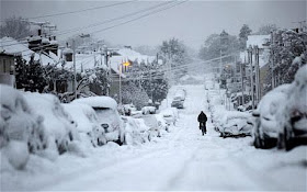
Image 1. Extreme and unusual snowfall in UK
Source: The Telegraph

How does less glacier means colder winter?
An article just published at the "Proceedings of the Academia Science of the United States" shows that Less Arctic sea ice alters atmospheric circulation leading to more snow and ice.

Without a substantial ice cover, Arctic wind is less constrained. Thus, the jet stream of cool air that regulates weather then dips farther and farther south, bringing cold air from the Arctic closer to the Equator. Hence, much colder weather extents into the spring much longer

Besides, Arctic ice locks up water molecules. Once the ice melts, the water molecules change into liquid state, which in turn will evaporate increasing the air moisture. Such moisture will eventually return to earth as precipitation; heavier precipitation than with less moisture. The precipitation may be either rainfall or snowfall. The point is, since there is more precipitation source (air moisture), it is reasonable to expect heavier precipitation.

References and Additional Reading

Tuesday, April 2, 2013

Technologies for detecting antipersonnel mines

Antipersonnel mines are explosive devices designed either to injure or kill humans. They are indiscriminate weapons that injure and kill civilians in every corner of the globe, every day. Moreover, antipersonnel mines do not recognize ceasefires and claim victims long after the end of conflicts. 
The 1997 Mine Ban Treaty, a.k.a. the Ottawa treaty, was signed in the Canadian city of Ottawa. Such treaty aims at eliminating antipersonnel landmines around the world. Nevertheless, there are doubts about its effectiveness, since countries like USA or Russia have not joined the treaty.

Since today is the UN day against mines, this article will  give a brief introduction of how technology contributes for detecting and removing personnel mines.
Image 1. Landmine field
Source: GenevaLunch

The technologies used for detecting landmines may divided into 5 categories: Metal detector technologies, Electromagnetic technologies, Acoustic / seismic technologies, biological technologies and mechanical technologies.

The technologies

Metal detector 
They are cheap and easy to use. They are magnetic sensors that send  current through a wire wrapped around a metal rod or loop, producing a magnetic field that penetrates the ground. Nevertheless, one disadvantage is that all metalic objects are detected. Although more sophisticated metal detectors may detect and see parts of less than 1cm, they cannot be detect new mines made of plastic material.

Electromagnetic
This technology is based on the emission of different radio waves signal into the ground and allow to construct an image of the detected object. Some of the most used electromagnetic technologies are: ground penetrating radar, nuclear quadropole resonance, impedance tomography, microwaves, infrared and ultrasound.

Acoustic / Seismic
This technology vibrates mines by introducing sound or seismic waves into the ground. If there is a material with different properties it will vibrate at different amplitude. The main disadvantage of this technology is that ground depth attenuates the resonant response. Besides, vegetation may interfere with the vibrometers.

Biological
The most common biological method is based on tranined animals that detect the smell of landmines buried into the ground. Although the most common animals are dogs and rats, new researchers have demonstrated that bees could search a large mined area in relatively short time.

A new biological methods consist of engineered bacterias that have certain characteristics when grown near a mine. The method would involve spraying bacteria on a mine affected area, and allow them to grow for several hours.

Mechanical
This method may be divided into probes and clearing machines. Probes are devices with a rigid metal stick that slowly penetrates the ground. When it detects an unusual object, it assesses the contour of the object in order to define whether it is a mine or not. The main disadvantage, is that it is an expensive method.  Mine clearing machines are used to clear a safe path over a mine field. It is basically a machine that detonates the mines. This is a quick and effective method, and the most important, it is riskless  Nevertheless, it basically destroys the field.

In 1996 the german humanitarian foundation "Menschen Gegen Minen" (MGM) (People against mines) was created. This organization not only removes mines, but also develops new and innovative mine detection machines. One of such machines is the MGM rotar.

The MGM ROTAR
The MGM ROTAR is based on idea of a relative lightly armoured system that could easily and safely remove the top soil, followed by a subsequent inspection.

The MGM ROTAR (Image 2) picks up mine infested soil with its rotating sieving drum. While sieving out the soil, objects with a diameter greater than the grid-size get left behind. The grid can be sized so that these objects including all known mine types. Should the mines detonate during the sieving process there is no danger to  the driver or the vehicle. Extremely strong steel and armoured glass protect the operator from the explosion and any fragments. The mines and pieces of unexploited ammunition that do not detonate as the ROTAR spins are dealt with safely later in a specially developed disposal system.

Image 2. MGM ROTAR

Thechnology and science provided us with several alternative to detect and remove antipersonnel mines. Howerver, removing aintipersonnel mines is just the first step. It is up to us, to have the will and the compromise, so that this threaten to life will never happen again.

References and Further Reading:
Menschen Gegen  Minen (People Against Mines)
The MGM ROTAR system, a new path for humanitarian demining
International Campaign to Ban Mines
UN Office for Dissarmament Affairs
A Review of Sensing Technologies for Landmine Detection: Unmanned Vehicle Based Approach