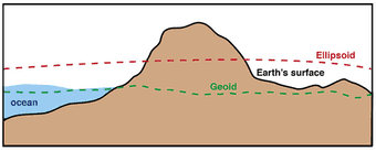
The Earth, our home, is not a perfect sphere. Its shape is more akin to a slightly flattened sphere, bulging at the equator and compressed at the poles. Understanding and quantifying this irregularity is crucial for various applications in geodesy, geophysics, and navigation. In this article, we delve into the concept of geoids, explore the significance of geoid height, and trace the development of EGM08, a milestone in geoid modeling.
Various countries have developed their own geoid models to suit their specific geographical and geodetic requirements. For example, Japan has introduced GSIGEO. With a grasp of the fundamental principles of geoids, it becomes straightforward to comprehend and calculate geoid elevations for any given geoid model.
What is a Geoid?
The geoid is a hypothetical surface that represents the mean sea level extended continuously over the entire Earth, accounting for variations in the planet's gravitational field and the shape of its surface.
It serves as a reference surface for measuring elevations on land and depths in the ocean, crucial for precise mapping and navigation.
Understanding Geoid Height:
Geoid height refers to the vertical distance between the geoid and the reference ellipsoid, a mathematical model approximating the Earth's shape.
Positive geoid heights indicate areas where the geoid surface is above the reference ellipsoid, while negative heights signify areas below it.
Geoid height measurements provide insights into the Earth's gravitational field and its irregularities, aiding in geophysical studies and satellite positioning systems.
Significance of Geoids:
Geoids play a pivotal role in geodetic surveys, where accurate determination of elevation is essential for infrastructure development, construction, and land management.
They are fundamental for satellite altimetry missions, helping to interpret oceanic circulation patterns, monitor sea level changes, and study geophysical phenomena.
Geoids are indispensable for global navigation systems like GPS, ensuring precise positioning and navigation across diverse terrains and environments.
Evolution of Geoid Models:
Geoid modeling has evolved over centuries, from early empirical approximations to sophisticated computational models based on gravitational theories and satellite data.
One milestone in geoid modeling is the development of Earth Gravitational Model 2008 (EGM08), a global geopotential model representing the Earth's gravitational field with unprecedented accuracy and resolution.
Development of EGM08:
EGM08 was developed by the National Geospatial-Intelligence Agency (NGA) in collaboration with NASA, the National Imagery and Mapping Agency (NIMA), and other international partners.
It integrates gravity data from satellite missions like GRACE (Gravity Recovery and Climate Experiment) and ground-based measurements to model the Earth's gravitational field up to degree and order 2159.
EGM08 provides geoid heights with a spatial resolution of approximately 10 kilometers, allowing for detailed geodetic applications and improving the accuracy of satellite positioning systems.
Applications of EGM08:
EGM08 has diverse applications in geodesy, geophysics, and Earth sciences, facilitating studies on crustal deformation, sea level variations, and regional gravity anomalies.
It enhances the accuracy of satellite navigation systems, enabling precise positioning for civilian and military purposes, aviation, and marine navigation.
EGM08 supports geophysical research initiatives such as climate modeling, oceanography, and earthquake monitoring, contributing to our understanding of Earth's dynamic processes.
Challenges and Future Directions:
Despite its advancements, geoid modeling faces challenges in accurately representing small-scale gravitational variations, especially in regions with complex geological structures or insufficient data coverage. It is adviced to contact specialized engineering firm with experience in this area.
Future efforts in geoid modeling involve integrating data from emerging satellite missions, improving computational techniques, and enhancing global collaboration to achieve higher resolution and accuracy.
Incorporating geoid models into interdisciplinary research endeavors, such as climate studies and environmental monitoring, will further expand their utility and significance in addressing pressing global challenges.


